Sunday, October 5, 2008
Exam structure @ 12:04 AM
This will be my last post for the year. The exam structure will be as follow for the sec 1 and sec 2.Section A (MCQ): 15 marks
Section B (Map work): 10 marks
Section C (Basic Techniques): 15 marks
Section D (Structured Questions): 60 marks
For sec 1, please take note that section D will have 20 marks for each of the chapters 10, 11 and 12.
Likewise for the sec 2 NA, you have 20 marks for each of the chapters 8, 9 and 10 in section D.
For the sec 2 express, you have 15 marks each for of the chapters 2, 3, 4 and 5 in Section D. The emphasis will be on these chapters and not on chapter 10 and mangreove.
Good luck to everyone.
Saturday, September 27, 2008
Exam tips @ 9:37 AM
For all levels, you need to mapwork, as dicussed, all must know 4 grid reference, contour interval, compass direction, measuring distance using a scale, physical and manmade features. For Sec 2, both levels need to know about settlement patterns. Sec 2 Express, you need to bring your protractor as you will to find bearings and 6 grid reference.All must bring a ruler, calculator and pencil for your mapwork.
For sec 1:
Chapter 10-
Water Cycle
River features for the upper, middle and lower course
Know the difference between a drainage basin and watershed
Delta formation and how distributaries deposit sediments to form floodplians
Benefits and problems of the river (different from dam)
Benefits and problems of the dam (different from river)
Chapter 11-
Annual rainfall
The difference and how to measure mean temperature and temperature range.
Read a climograph
Read a max min thermometer (look only at the bottom part of the metal indicator, usually black in colour)
Know your weather equipments like rain gauge, stevenson screen, wind vane and wind rose
How wind is created.
How to read a wind rose.
Know how to read a rainfall map (Basically, know where there is more rainfall on the map, bigger the number, higher the rainfall.)
benefits (consistent pattern) and problems (inconsistent pattern) of weather and climate to people.
Chapter 12-
Distribution, climate, feature and adaptation of plants. Follow the worksheet and you will be fine.
benefits of vegetations (check the last pages of chapter 10).
Sec 2 N(A)
Chapter 8-
Features and problems of 4 national taps
Vulnerability due to water shortage
How to conserve water
Chapter 9-
Cause, effect and prevention of air, land and water pollution
How acid rain is formed and its damages
3Rs at International, National, Individual level
Chapter 10-
Cause, effect and prevention of global warming and ozone depletion
Know that the only link between global warming and ozone depletion is CFC as it is a greenhouse gas, global warming does not cause ozone depletion.
Montreal Protocol is for reducing ozone depletion and Kyoto Protocol is to reduce carbon emission to stop global warming.
Sec2 Express
Chapter 2:
Rate of natural increase
Factors of high birth rate, low birth rate, high death rate, low death rate
How government can help with each of the rates except low death rates
How to read a population pyramid
Chapter 3:
The difference and features and purpose of each settlment pattern.
Amenities, transportation, communication, main economic activities and lifestyles (education, income, stress level) of a rural and urban settlement
Chapter 4:
Know the steps for each farming methods, slash and burn purpose, monoculture in plantation, etc
Inputs and outputs for each farming method.
The difference in subsistence and commercial farming.
Chapter 5:
What is a transport and communication hubs?
How transport and communication hubs can lead to globalisation to a shrinking world and promote entrepreneurship.
Chapter 10:
Cause, effect and prevention of global warming and ozone depletion
Know that the only link between global warming and ozone depletion is CFC as it is a greenhouse gas, global warming does not cause ozone depletion.
Montreal Protocol is for reducing ozone depletion and Kyoto Protocol is to reduce carbon emission to stop global warming.
Sec 1 answer scheme to excercise 12.1 to 12.6 @ 8:34 AM
Excercise 12.1Q1a:
Natural vegetation=Plants grown naturally and not by man.
Major types=Forest, Grasslands, Deserts
Sub types= Forest-(Tropical rainforest, Temperate deciduous forest, Temperate coniferous forest), Grass land-(temperate, tropical), Deserts-(Hot, cold tundra)
Q1b(i):
Temperature, sunlight and rainfall
Q1b(ii):
Higher rainfall and sunlight lead to greater plant density and higher temperature often leads to greater variety of plants.
Excercise 12.2
Q1a: 50 to 30m-emergent, 30 to 10m-canopy, 10m and below-undergrowth
Q1b: Unable to show you due to copyright issues.
Q1c:
Emergent:
Feature=Tall, up to 40 to 50m in height.
Reason=To bypass the canopy to get more sunlight.
Canopy:
Feature=interlocking crowns
Reason=to block sunlight to the undergrowth
Undergrowth:
Feature=Sparse undergrowth
Reason=little sunlight
Q1d: again copyright problem.
Excercise 12.3
Q2a: Buttress roots, to help support the tall tree.
Q3c: Broad to get sunlight, Drip tip and waxy to remove water from the leaf surface to get more sunlight.
Q6: Little sunlight due to interlocking crowns of the canopy.
Q7: Sparse (little) vegetation, damp ground.
Excercise 12.4
Layer:
3, 3, 1
Leaves:
Tropical=evergreen, drip tip leaves, broad.
Deciduous=colour changes to the seasons, broad, leaves are shed before winter.
Coniferous=evergreen, small, needle like, waxy
Characteristics:
Tropical=close to each other, sparse undergrowth, interlocking crown at canopy and tall emergent trees have buttress roots
Deciduous= new leave in Spring, full crown of leaves in summer, leaves brown in autumn and shed before winter.
Coniferous= one species in a large area, cone shaped, tree branches can bend to get more sunlight or remove snow.
Temperature:
Tropical=20 to 30
Deciduous= -2 to 18
Coniferous= -12 to 10
Rainfall:
Tropical= 1000 to 2000mm
Deciduous= 750 to 1000mm
Coniferous= 300 to 750mm
Places:
Tropical= South East Asia, Brazil
Deciduous= America, Japan
Coniferous= Alaska, Northern Europe
Plants:
Not important
Excercise 12.5
Feature:
Tropical:
few trees, alot of grass, prone to bush fire, experience 7 to 9 months of rainfall and a long dry season.
Temperate:
Few or no trees, tall grasses, windy environment
temperature:
Tropical:
20 to 30
Temperate:
-20 to 10
Rainfall:
Tropical:
200 to 1000
Temperate:
200 to 1000
Excercise 12.6
Q1a:
A-tundra, B-hot desert
Q1b:
A is cold and dry, mostly covered in snow.
B is hot and dry.
Q1c(i):
Q and R
Q1c(ii):
Q is to spread out to look for more water and R is to get groundwater
Q1d:
Long and deep roots to get more water
Small and waxy leaves to reduce water loss
Large swollen trunk to store water
Small plants have short life cycle to reduce water demand and seeds grow only when there is water.
Tuesday, August 12, 2008
Common test @ 1:27 AM
Sec 1 Express: chapter 10 and 11Chapter 10-Parts of the river in the upper, middle and lower courses, hydrological cycle, deposition and erosion in the meander, benefits and problems of the river and the Aswan High Dam (Please know the difference!!!)
Chapter 11-Difference between weather and climate, climograph, parts and purpose of a stevenson screen, rain gauge, calculate annual rainfall (total rainfall), temperature range (diff bewteen highest and lowest), mean temp(average temp), how wind is created and the instrument to measure wind.
Sec 2 N(A): Chapter 8 and 9
Chapter 8- 4 national taps, water conservation.
Chapter 9: Causes, effects & prevention of air, water and land pollution.
Sec 2 Exp: Agriculture
Learn the input and output of each farming method and the key processes, learn about the benefits, problems and solution for green revolution.
Follow as I how teach you all to study and you will be fine.
Worksheet 11.2 answers for sec 1 express @ 1:19 AM
Q1a: 34°C, 23°CQ1bi: It should be placed at B, it is an open space with no obstruction.
Q1bii: A is too near the wall. C is on a hard surface and will reflect heat from the sun. D is under a tree and the screen will be under a shade.
Q1ci: 33°C-21°C=12°C
Q1cii: (33°C+21°C)/2 = 27°C
Q1ciii: The temperature is lowest in the morning at about 1am and the highest at 1pm in the afternoon.
Q1di: Rain gauge
Q1dii: see notes
Q1diii: The funnel is direct water into the collecting cylinder and the outer casing is prevent backsplash and water from the surrounding from getting in.
Q1div: 1489mm (add all up)
Q1ei: in an open field to avoid obstruction or at the top of a tall building to get a clearer view
Q1eii: Northwest.
Sunday, June 22, 2008
Things to look out for second semester 2008 @ 2:46 AM
Semester 2 is really short, you have effectively 3 months of study and Bang! Exams are on the door step.I think right now I will share with you that you should look at the Exams and what you have to study as a whole. Semester 1 work will not be tested. So very lucky of you.
Anyway, for the sec 1, please take note of:
1. Parts of the river and how they are formed
2. How people depend and pollute the river.
3. Weathers & climates, what is the difference, how to measure temperature, rainfall and wind.
4. Types of climate, where each climate is found.
5. Types of vegetations and how they survive in each climate.
For the Sec 2(NA), really easy stuff:
1. Water supply, how Singapore deals with water shortage.
2. Pollution, seperate them into air, water and land and whether they are local, regional and global.
3. Global warming and ozone depletion, what cause them, what effects and what we can do about it.
4. Tropical rainforest adaptation, revision of sec 1 work, this might or might not come out, depending on the time allowed.
For the sec 2 Exp:
1. Learn the human environment through the 4 parts: Population, transport & communication, agriculture and housing, know how each is connected and affect one another.
2. Mapwork will come back again to haunt you. MUAHAHAHAHA! *cough*
Congratulations to all top students @ 2:38 AM
The following are the top students for each class for the mide year examination:2H: Claudia Tan Li Yi
2C: Ron Woo Hong Jie
2B: Dania Syazana Bte Shafi'e
2A: Cheryl GOh
1H: Nur Aminuddin B Bidin
1G: Daryl Lim You Quan
1F:Wong Hong Hui
1E: Chong Wai kit
Congrats to you all.
Sunday, April 27, 2008
Exams for sec 1 & 2 @ 7:24 AM
For the sec 1, please take note that chapter 1 & 7 is not tested. I will explain to you what you should be covering for each chapter.Chapter 2- Essentially about characteristics about Earth, like its orbit, rotation, etc.
Chapter 3- The difference between the physical and human environment and how the !kung bushmen and the city people adapt to their environment. Lastly, how the human environment changes to suit people's needs.
Chapter 4- I will not be testing on the different types of maps, longitudes & latitudes, but I will be testing on the international timezone and you must know the parts of the map.
Chapter 5- Learn your 4 and 6 grid reference, cross section drawing of landforms, how to find actual distance on the map using the scale, bearings and compass direction. I will not be testing on gradient and curve line distance. The grid box distance is exactly 1cm both in height and width, so use your ruler and measure the 6 grid reference, instead of estimating.
Chapter 6- Be able to tell what is foreground, midground and background based on the features found in the picture. Know what is a landscape, aerial and satellite photo and how each are different. Questions here is tougher than before, so read what the question is asking carefully, before answering.
Chapter 8- Read and remember all the facts, that is all.
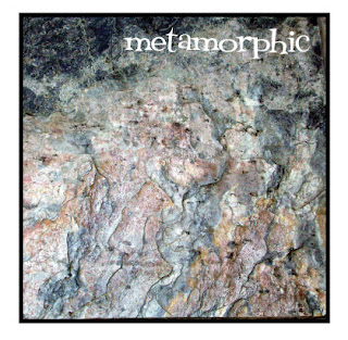
Chapter 9- know how igneous, sedimentary and metamoorphic rocks are created, know how each rock looks like and an example of each type of rock.
For the sec 2 N(A),
Chapter 2-Know your population pyramids and whether it represents a developing country or developed country based on the children, working and elderly population group. Know the difference between population density and distrbution. Know what are the factors that lead to increase and decrease in birth and death rate.
Chapter 3- Know what is a rural and urban settlement and the 3 different types of settlement patterns.
Chapter 4- Understand what is shifting culitvation, the steps involved and the slash and burn method. Know the difference between subsistence and commerical farming, what is the difference between subsistence and commercial wet rice cultivation. Know the advantage and disadvantages of high tech farming.
Chapter 5- Know the types of communication (printed media and telecommunication) and transportation, what is globalisation, what is entrepreneurship, what is a transport hub and how the world has become smaller.
Chapter 6- High human population and advancement in technology has lead to increase in pollution, know an example on how pollution occur at local, regional and global level and how the 3Rs can be done at individual, national and international level.
Chapter 7- Know how we are running short on land, how we can increase land supply and the problems comes with it, what is price mechanism, what is opportunity cost. Learn also what is mixed landuse, how we can increase farming land and its problem and why conserving land for the environment is important.
For the sec 2 express,
Learn how the fruits, flowers, roots, leaves of the tropical rainforest and mangrove forest help the trees adapt to their environment.
For pollution, global warming and ozone depletion, learn about the causes, effects and preventions. For chapter 6, refer to the sec 2 N(A), it is the same.
That's all for now.
Chapter
Monday, March 31, 2008
Volcano links for sec 1 @ 7:20 AM
Here are the links I have for the volcanoes:Formation of a volcano
http://dsc.discovery.com/beyond/?dcitc=w17-502-ag-0000&videoRef=9d87090878264eb932fa2032ea1bbada3a920658
interactive volcano
http://dsc.discovery.com/convergence/pompeii/interactive/interactive.html
Pliny's account
http://dsc.discovery.com/convergence/pompeii/pliny/video.html
Pyroclastic flow
http://dsc.discovery.com/convergence/pompeii/videogallery/videogallery.html
Monday, March 17, 2008
Where are the bees? @ 5:40 AM
Read up on this site: http://viewzone.com/lostbees.html
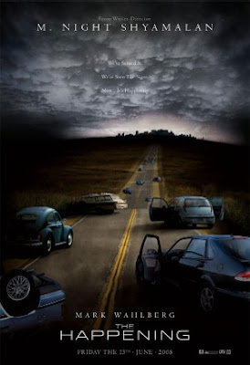
It is about the lost bees, Einstein said that if the bees disappear, man will disappear in a few years time. What's your take on it.
A new movie by M. Night Shyamalan is based on the missing bees and what could happen to man as a result, below is a trailer on the movie:
Sec 2 N(A) project @ 4:13 AM
Ok here for all the sec 2 normal classes, here are the details again:
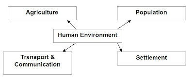
The project is on creating a mind map or a flowchart on a vanguard sheet or equivalent poster size (larger scale posters are allowed too, not smaller) on the four factors of the human environment: Population, Settlements, Agriculture and Transport & Communication. It will be based on chapter 1 to 5 of your textbook.
You will need to form into groups of 2 or 4. Those who are in groups of 2 will automatically get 10 points extra.
The dateline of your project will be on 19th March 2008, Wednesday.
The diagram below is a simple example of what is expected of you.
You will need to form into groups of 2 or 4. Those who are in groups of 2 will automatically get 10 points extra.
The dateline of your project will be on 19th March 2008, Wednesday.
The diagram below is a simple example of what is expected of you.
The project will be awarded upon the following criteria and is upon a total of 50 marks:
Completion of at least 6 components of each factors above in the diagram. (25 marks)
Completion of at least 6 components of each factors above in the diagram. (25 marks)
Additional information on each component and additional factors. (10 marks)
Additional linkages to each contributing components or factors with explanation. (15 marks)
Bonus marks of up to 15 marks will be given for additional pictures and charts with explanation and links to the chart. (15 marks)
Bonus marks of up to 15 marks will be given for additional pictures and charts with explanation and links to the chart. (15 marks)
Sec 1 guide books and other stuff for sec 1s. @ 4:13 AM
Please take note that the books should be in by next week. The bookstore keeper is currently trying to remove the GST for you all, so does who paid extra for the GSTwill get a refund if he manages to get the discount.Sorry for not writing lately, been really busy and sick with flu too. Anyway, given how you all are not comfortable with map reading, I am going to go through it nearing the mid year exam.
For photograph interpretation, here are some ground rules:
1. Only landscape and aerial photos taken at an angle can be splitted into 3 parts: Foreround, midground and background. Be aware of your perception, things further from you are always smaller.
2. Describe what you can see and identify. Do not describe something you cannot see clearly or explain clearly, especially in satellite photos.
3. If you are not sure but you want to explain a weak point across, provide a good argument. For example, you see a man standing on the roadside, you can suggest that the man can be crossing the road or you can say he is waiting for a cab. A weak point is when you say he is waiting for someone. To put your point across, a good argument could be is he is not looking at the oncoming traffic, so he could be waiting for someone. That is how you can score more.
Thursday, February 21, 2008
Chapters to study @ 12:56 AM
For sec 1 express students:Chapter 1 to 5, exclude curve line measurement and definitions on types of landforms.
For sec 2 express students:
Mangrove notes, chapter 6 and chapter 9 (on air and land pollution)
for sec 2 N(A) students:
Chapter 1 to 3.
Wednesday, February 20, 2008
More common test tips @ 5:28 AM
For the sec 2 (NA), as explained in class, I indicated that the mind map is important and it will reflect well on what is needed to be known. Focuse on describing population pyramids and that bigger the area, the bigger the population. For settlements, you should focus on the 3 types of settlement patterns and how each pattern is formed by certain key factors.For the sec 2 express, please learn about air pollution, particular about haze in Singapore. Roots and fruits of a mangrove tree too is important. I cannot say much about the other questions, but be aware of those questions that are from chapter 6, read the question carefully, the answers are not so direct.
For my sec 1s, I have ask you all to do workbook 5.2, given the time constraint, I will share the answers with you now.
(a): A is legend, key or symbol, B is north arrow, C is scale.
(b): 1:50,000
(c): 5747
(d): Above 1050m
(e): 16º(±1º)
(f): 800m
(g): 575444
(h): Houses, a mountain
(i): A steep slope, there are closely spaced contour lines.
(j): 565462
Monday, February 18, 2008
Trignometrical stations for sec 1s @ 4:22 PM
Trigonometrical stations are key points that show the height of a hill or a mountain and is the highest point of the physical feature. On a topograohical map, the trig point will have the highest point value in metres. For more details and how it looks like, refer to your textbook page 34.
You can go this website at: http://en.wikipedia.org/wiki/Trig_point and to find out more why and how they are used refer to: http://en.wikipedia.org/wiki/Ordnance_Survey. At the bottom of the last website, you can find links to different organisations around the world that work on this surveying of our Earth.
Hint: I hear a test round the corner ask about the highest point.
Tips for the common test for sec 1s @ 4:32 AM
Hi all, sorry for the late entry, but here are the stuff for you all to learn.For chapter 1, know what is a feature and a environment, know the difference betwen physical and human features.
For chapter 2, learn the Earth's movement and how they create the seasons and what happens to that annoying 1/4 day for each year.
Learn chapter 3 well, many of the questions will be coming from there, things about why is it important to protect our Earth, how the !kung bushmen and city people relationship with their environment.
For chapter 4, know about international time zones, your textbook is more than sufficient to explain what you need to learn. Latitudes and longitudes too are important, learn how to use them. The world map as shown on your notes is important too.
For chapter 5, please take not on the reading of 4 and 6 grid reference (REMEMBER: EASTING-the vertial lines are read FIRST, then NORTHING-the horizontal lines are read next, no commas or dots are needed)
Be able to determine your compass direction and bearings.
Know how to find the contour interval.
Know what is the highest height you can read on the map, look at the contour lines.
I will try to update more along the way before the test itself.
Monday, January 21, 2008
ANNOUCEMENT!! ALL Sec 1 and Sec 2!! @ 11:34 PM
For Sec 1 students,Please take note that you all are having a class test this week, study chapter 1 to 3. For the common test, study up to chapter 5. I might add in chapter 6 too if we can finish everything on time. Do not fret, chapter 6 is not hard.
For sec 2 students,
For sec 2H, class test is this week. Learn everything on the photocopied notes as the questions are from there. For the IPW, all are encouraged to head down to Sungei Api-Api on your own.
And all the sec 2 N(A) classes that I teach, next week test will be on population, look at your workbook, we will be working mainly on the questions about population charts. It is not hard and I will go through with you again this week.
Monday, December 31, 2007
@ 12:53 AM
MERRY BELATED CHRISTMAS!
& HAPPY NEW YEAR!
The new forum URL is http://spf2007.forumotion.com
I've alr created a link to the forum so click it (:
& if u have been banned from the forum tell Mr.Tan or Jeneva or Me(Amelia).
We will unban u or try to see wat the problem is..
As for the tagboard just tell me (:
Happy Holidays All!
See you next year :D
the-opendoorsamelia
Sunday, December 2, 2007
Happy Holidays everyone @ 4:59 AM
Hi all,I hope everyone is enjoying your holidays. I know my post these days have been far and few, but I guess there is nothing much to report of yet. Anyway, here are the top sec 1 students for the final Geography exams. I know many of you got upset taking the photos (hee,hee,hee), but it was worth it. So here they are:

From Sec 1A: Clement Tan

From Sec 1B: Syarafuddin (see I spell your name correctly!)

From Sec 1C: Ron Woo

From Sec 1E: Sandeep
From Sec 1F: Kiran! Again!

From Sec 1G: Gina Wang (so glum...)

From Sec 1H: Jia Lyn & Claudia (Look so happy! hahahaha!)
Anyway, please take note I might be taking Sec 2E, 2F and 2G next year, as we all have to prepare you all for IPW, which is inter-disciplinary event between Geography and Science. Hopefully I can take your classes all again for Semester 2 after the IPW is over. Will keep you all updated.
Thursday, November 1, 2007
Change of Forum address @ 5:42 PM
The forum address has been changed to www.spf2007.forumotion.com. Expect some changes to the layout in time to come. As discussed before, I will be handing administration rights to your relevant subject teachers. Also, you have a new administrator among you all, who is Geneva Apolinar from 1E, she will be working together with Amelia Tay.If you have any problems with the forum, please contact them or me.
Lastly, check for updates on who will be teaching you all next year, it could be me or Miss Jenny Goh.
Enjoy your super long holiday! =)
Monday, October 8, 2007
Bad news for the Bukit Timah Trip @ 8:31 PM
I like to apologise to everyone that the Bukit Timah Nature Reserve Field Trip for this year is cancelled. This is due to the issue that we do not have the allocated dates to take you all there. As a result, this trip will be postponed to next year.If you have any idea what we should do for next year, please post it on the forum and I will see if it can be feasible.
Thursday, October 4, 2007
stuff to bring for exam @ 6:32 AM
Please bring your CALCULATOR & RULER tomorrow. Please inform your class mates too. I will try to come to school earlier, since so many of you are crying for help.Saturday, September 29, 2007
Added notes on the exam @ 7:50 PM
Please remember that in the exam, that for every marks you are given, you must write down at least one point. For example, if the questions is worth 4 marks, you must write down 4 points for your answer. If you are not sure of your answer, write down more to be on the safe side.Lastly, for the express stream, please take note that your paper is harder and so you must know your facts well. Stick to what I say about using the rubric for the natural vegetations and you will be fine. Here is a example of what you can do:

Take note that for the Normal classes the rubric is the same for you all for chapter 18, but you do not need to learn about the adaptations and distribution. However you do need to need to know the adaptation and dstribution of the tropical rainforest. You can find your information in chapter 19.
Friday, September 21, 2007
Exam, exam, exam @ 10:52 AM
Please take note that the exam questions will be based on chapter 14 to 21, N(A) classes will not need to learn chapter 20 and deciduous and coniferous forest in chapter 19.What to take not of in the chapters:
Chapter 14:
Learn the Benefits and problems that the river brings and the same for the Aswan High Dam. PLEASE know the difference between the dam and the river!
Chapter 15:
Learn about calculating annual rainfall, mean temperature & temperature range. Find out about parts and placing of the rain gauge and stevenson screen.
Chapter 16:
Find out the distinct features of the climographs of the three climates, polar, temperate and tropical.
Chapter 17:
Learn about the types of positive and negative effect of the weather and climates.
Chapter 18:
The 3 main types of vegetation and for the express class, which countries they are found.
Chapter 19:
How plants adapt in each natural vegetations and the importance of Bukit Timah Reserve.
Chapter 20:
Read my notes.
Chapter 21:
Examples of the 4 main types of benefits vegetations provide and the actions that can be taken at the 3 levels of protecting natural vegetations.
Be prepared for the class test next week. For the express class, you will have only your textbook for use, while the N(A) classes can use both their files and textbook. It will be open book all the way and you have 40 minutes to do your test.
Remedial is this Monday at 2 to 3pm, I cannot promise you if there can be another remedial in the week, but I will keep you updated.
Lastly, use the forum as much as possible and encourage others to do so, do not underestimate the power of the forum when it comes to exam time.
Friday, September 7, 2007
The Forum and the exam matters @ 2:05 AM
Hi all,It's been a while since I wrote on the blog, so here is the good news for you all. The forum is up! The link is http://www.spf-geog.forumotion.com/. Please register in by your username which is your the initials of your name plus your surname at the end. For example: John Tan Jia Wei will JJWTan. Your password will be of your own choice, so long you can remember it and no one can find out about it.
When school starts next week, all of you must submit your username and password to your class moderator and a copy to me for safekeeping and for security reason where anyone using vulgarities or making rude remarks online will be dealt with under school rules.
If you are going to discuss on the broader thread for everyone, please indicate your class and username at each message. For example: 1G-JJWTan.
Here are some helpful tips, in case of any matter
TO RECOVER A FORGOTTEN PASSWORD, use this address :
http://spf-geog.forumotion.com/profile.forum?mode=sendpassword
Do not hesitate to use the support forum for all the questions about the use of your forum :http://help.forumotion.com/
EXAM MATTERS
For the express class, please take note that you will have to study everything from chapter 14 to 21 and for the normal classes, you will cover chapter 14 to 21, excluding chapter 20 and the last part of chapter 20 which is about the deciduous and coniferous forest. The normal classes will also not be required to know where each natural vegetation is located in each part of the world.
I will be conducting a remedial class for the express stream every Monday from 2 to 3pm in the IT Resource Room 2 starting next week for the next 3 weeks. All express students who had failed the common test from 10 marks to 14 marks are required to attend.
As for the normal classes, I have covered everything, so the next 3 weeks will be revision and more revision. So there is no reason to fail.
Monday, August 20, 2007
Bukit Timah Nature Reserve @ 7:18 AM
All right, let me just say that for this topic, it is really easy and that you can also check on this 2 websites that have the right mix of information about Bukit Timah Nature Reserve. For all the sec 1B students, this are the links you have to read up.http://www.ecologyasia.com/html-loc/bukit-timah.htm
http://www.nparks.gov.sg/nature_bukit_biodiversity.asp
You can find alot more information in the second link where there are more hyperlinks on the page itself that will tell you more about the Bukit Timah Nature Reserve.
For those of you who cannot excess the moodle for some reason or another, here is a version of the worksheet here, copy all of the words below and place it in Microsoft Words, print it out and there you have the worksheet for yourself. Please take note that this is mainly for sec 1B for their E-learning day.
For the rest of you, this is a good reading site for you all, please take note there will a be class test in 2 weeks time (last week before the school holidays). It will be on chapter 19 (until Bukit Timah Nature Reserve) and 21.
______________________________________________________________
Name: ___________________________ ( ) Date: _______________
Class: ___________ Marks: __________
Bukit Timah Nature Reserve worksheet
Read up on Bukit Timah Nature Reserve on the following hyperlinks and answer the following questions.
http://www.ecologyasia.com/html-loc/bukit-timah.htm, http://www.nparks.gov.sg/nature_bukit_biodiversity.asp
What would happen to the fig tree or the fig wasp if either of them disappeared?
________________________________________________________________
________________________________________________________________
Name 1 benefit the rattan plant can provide to people.
________________________________________________________________
________________________________________________________________
Name 3 types of plants that can be found in Bukit Timah Reserve.
________________________________________________________________
________________________________________________________________
Name 2 human actions that have caused damage to the Bukit Timah Tropical rainforest?
________________________________________________________________
________________________________________________________________
________________________________________________________________
________________________________________________________________
________________________________________________________________
Give 3 important reasons to conserve the Bukit Timah tropical rainforest?
________________________________________________________________
________________________________________________________________
________________________________________________________________
________________________________________________________________
________________________________________________________________
________________________________________________________________
Why do you think that the tropical rainforest in Bukit Timah has far more species of plants than the whole of North America?
________________________________________________________________
________________________________________________________________
________________________________________________________________
End of paper.
Friday, August 10, 2007
Common test info @ 3:28 AM
For a start, it is chapter 14 to 18. I will keep it brief and I will answer questions for the next few nights till the common test.Chapter 14:
Know briefly what are the advantages and disadvantages the Aswan High Dam brought to the Eygptians, you do not need to know about the salinity, I will not require you to know.
Chapter 15:
Know the difference between weather and climate.
Know how to calculate annual rainfall, mean temperature and temperature range for daily, weekly, monthly and annually.
Before you start screaming your head away at the formula, READ CAREFULLY the similarity for the temperature formula, the only difference would be that the MEAN DAILY TEMPERATURE IS (HIGHEST TEMP + lOWEST TEMP)/2.
Know a few things about the Stevenson screen and the rain gauge, it is all in your notes.
Chapter 16:
There are only 3 climates to learn: Tropical, Temperate and Polar. Know how to recognise the climograph for each climate.
For tropical, it NORMALLY has high rainfall, high temperature & low temperature range. Meaning it will have alot sunlight & high humidity.
For temperate, it NORMALLY has evenly distrubuted rainfall & high temperature range. Meaning it has the 4 seasons and temperature can range from hot (above 21ºC) to cold (below -10ºC)
For polar, it NORMALLY has low rainfall, low temperature and low temperature range. Meaning the area is normally covered in ice and snow, with little rainfall, sunlight and humidity. There is a possibility that there might be a short period of time in the centre of the year where the temperature will be higher than normal with similar amount of rainfall.
Chapter 17:
Know the positive effects (consistent weather and climate pattern) and negative effects (inconsistent weather and climate pattern).
Positive:
1. Wind and solar energy
2. Tourism
3. Farming
Negative:
1. Drought
2. Flooding
3. Heat wave
4. Cold wave
5. Extreme wind
Chapter 18:
For the normal stream, you do not need to know the latititude or the locations, but you need to recognise the vegetation from the picture and describe the climatic factors for the plants there like rainfall, temperature and sunlight. Remember that the higher the rainfall, the more plants. Sunlight and temperature go together.
For the express stream, you must be able to know which form of vegetation exist based on the climograph, look at the annual rainfall to decide if it is a forest (above 750mm), grassland (below 750mm) and desert (below 250mm). Then to decide which sub categories they belong to, look at the temperature. For example, high rainfall and high temperature means it is a tropical rainforest. Low mean temperature (below -10ºC) and higher rainfall & temperature in the middle of the year means it is a coniferous forest. I know this is hard, but do not worry I will not set hard questions in this chapter. To help you better undertsand this chapter, read up on this sites to better help you, it will also help you for chapter 16.
Tropical rainforest:
http://www.uwsp.edu/geo/faculty/ritter/geog101/textbook/climate_systems/tropical_rainforest_1.html
Temperate deciduous forest:
http://www.uwsp.edu/geo/faculty/ritter/geog101/textbook/climate_systems/humid_continental.html
Coniferous forest:
http://www.uwsp.edu/geo/faculty/ritter/geog101/textbook/climate_systems/subarctic.html
Tropical grassland:
http://www.uwsp.edu/geo/faculty/ritter/geog101/textbook/climate_systems/tropical_steppe.html
Temperate grassland:
http://www.uwsp.edu/geo/faculty/ritter/geog101/textbook/climate_systems/midlatitude_steppe.html
Hot desert:
http://www.uwsp.edu/geo/faculty/ritter/geog101/textbook/climate_systems/tropical_desert.html
Tundra:
http://www.uwsp.edu/geo/faculty/ritter/geog101/textbook/climate_systems/tundra_1.html
I do not expect you to know everything form these sites, they are there just to give you a better understanding of things.
Tuesday, July 10, 2007
@ 5:56 PM
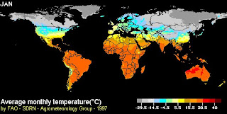
I like to inform you about my mistake on page 129 of the textbook. The map's legends are correct, the legends are correct to each region, as they are actually representing the TEMPERATURE RANGE, not the MEAN TEMPERATURE for each region. Nonetheless, do not worry about it, refer to my notes as it would give you a better description about climatic maps.Sunday, July 8, 2007
@ 5:46 PM
For the last part of the chapter 15 which I will be covering this week, climographs and wind rose are the more difficult ones to learn.
For the weather map, you must be able to evaluate what does wind speed, wind direction, rainfall and temperature will tell you about the atmosphere in the area. The next thing is to figure correctly what would possible happen in the next few hours based on the information present.
For example, If there is sky is cloudy, strong winds are present and the temperature is cooler than normal, what would possibly happen in the next few hours? If you say it is going to rain, you are on the right track. If you say otherwise, well I guess you better get out more and look at the sky more often. ;P
Next thing is climatic map or commonly known as climate map, please note that the legends of the climatic map on page 129 of your textbook is wrong, please ignore the entire map, you will get more confused reading it. Climatic maps are used to tell what kind of climate exist in the world or in regions of the world, such as the one below. They normally tell you about the temperature or the amount of rainfall in each area.
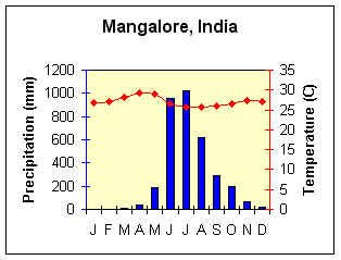
As for climographs, they are the most common charts used to describe the climate of a region over a period of one year. They normally tell you about total rainfall and mean temperature for each month of the year. It is hard to get accurate reading from them when you start calculating, but I will normally give a generous buffer in the deviation, so don't fret unnecessarily.
I recommend using a ruler to measure correctly, when finding the annual rainfall and the annual mean temperature. Try doing it first and you will get what I mean. Here is an example of a climograph, notice that the rainfall reading are the bars and the temperature are connected dots.
This site has alot of information that will help you in your studies about climographs. (Hint: also alot on chapter 16, use your textbook as reference)
Next up is the wind rose, unfortunately, I cannot explain in great detail here, as it will need some personal guidance, words just do not describe well how it works. Don't fret again, it is not hard. If you need some assistance to understand, this site will help you.
That is all for now, there will be an open book test on this chapter worth 20 marks. Do well in this because it will help you alot in the following class test and common test.
Tuesday, June 26, 2007
Of tests, exams and chapter 15 @ 6:43 PM
Tentatively, there will be tests every week, only unless there are holidays or other events that clash during that week. Nontheless, with only 12 weeks in this term to teach you all 7 chapters for the normal classes and 8 (chapter 20 included) for the express, I recommend all to read up the following chapters before coming to class.
The exams will include chapter 14 to 21 (exlcuding 20 for normal classes), this time round it should be easier than the first semester's exam, so I am expecting much higher number of passes.
Next, in order to prepare you for chapter 15, here are a few major tips (which actually if you read your textbook, you do not need)
1. Max & min temperature
mean (mean = average) temperature: (max-min)/2 ....duh
2. temperature range
max temp- min temp
3. Rainfall
READ THE BOOK, VERY STRAIGHTFORWARD.
4. Wind Rose
The one with the longest arm shows which direction the wind is blowing most constantly. Take note that a wind rose is NOT a wind vane. Here are 2 pictures to show you the difference.


The one on the left is a wind vane and the one on the right is a wind rose.
The rest of the material I will present in class, it is a fun topic and I think you all will enjoy it.
Tuesday, June 12, 2007
Happy Holidays and notes on Rivers & People @ 6:07 PM
Happy holidays, hope everyone is enjoying their holidays. Anyway, remember to do review exercise. The things to take note about chapter 14 is that there are both positive and negative impacts that the river can have on people. The positive impacts that rivers have on people can also lead to people abusing the river for those uses and in the end polluting or damaging the ecological system in the river. I will not go into too much detail, as I can see alot of you understand this part of the chapter.Please take note that the River Nile and Aswan high Dam case study is different from the rest of the chapter, as it builds upon your understanding from the earlier part of the chapter. The problems and benefits that the Aswan High Dam can be summarised as followed:
Benefits:
1. Hydroelectric energy.
2. Water level is same throughout the year.
3. Crops can be grown throughout the year.
4. Boats can travel up and down the year throughout the year.
5. Arid (dry and infertile) land now be irrigated (watered) to become arable land (land is good
Question: Why does point 3, 4 & 5 related to point 2.
Problems:
1. Less sediments are flowing down the river.
2. Farmland down river are less infertile.
3. Fish population are reduced.
4. Habitats are reduced, animals and plants species and populations are reduced.
5. People have to leave their homes and houses upriver.
Question: Why does point 2, 3 & 4 related to point 1.
Here are a couple more sites you can go and read up about.
http://geography.about.com/od/specificplacesofinterest/a/nile.htm
http://en.wikipedia.org/wiki/Aswan_High_Dam
here is a site on arid and arable land:
http://geography.about.com/od/physicalgeography/a/deserts.htm
http://en.wikipedia.org/wiki/Arable
Those of you who are going on holidays, take some photos of what you think is arid (dry) land and arable (fertile) land. A good tell tale sign if it is barren with little plants (arid) or is any farming (arable). We can share the photos when we come back to schoool.
Wednesday, May 30, 2007
@ 9:04 AM
 If you want to know more about active volcanoes in the world visit:
http://www.geo.mtu.edu/volcanoes/world.html
Wednesday, May 16, 2007
TYPE OF ROCKS @ 8:05 PM
THERE ARE THREE BASIC GROUPS OF ROCKS:TO KNOW THESE TYPES IN DETAIL,
TO KNOW THEIR EXAMPLES,
TO EVEN KNOW THE "ROCK CYCLE",
VISIT http://www.promotega.org/ksu00006/types.htm
Sunday, May 6, 2007
Exam Tip 4 and final tip @ 6:58 AM
I anm quite tired of you all asking me what chapter to study, It should have been obvious from the chapters I covered, chapter 1 to 13 excluding 7. Focus less on chapter 1, it is not the most important. All classes please take note to collect you test papers and files back from the pigeon hole.
Anyway, let me continue with the rest of the tips for the following chapters, it will be very straightfoward.
Chapter 8:
Know your landforms, like what is a valley, plateau and plain. The difference between hill and moutain.
Know the 3 types of benefits landform can bring about. And how mountains can be a natural barrier and the dangers living on a mountain.
Chapter 9:
The 3 layers of the Earth: Crust, mantle and core.
Understand the crustal movement and what is convection current in the mantle and what it does to the crustal plates.
What is folding process and how fold mountains are created.
What is vulcanicity and volcanic eruption.
Parts of the volcano: magma chamber, pipe, vent, crater. Remember cone is not part of a volcano, it is the volcano.
The 3 types of volcano: active, dormant and extinct.
Chapter 10:
The benefits of living next to a volcano: fertile soil, mining minerals like gold , getting geothermal energy, tourism, cultural and traditional icons and lastly jobs and improve economy (state how they produce jobs and improve the economy)
The dangers: Vulcanic bombs, poisonous ashclouds and lava flow. You know the story behind it all.
Chapter 11:
The difference between weathering (breaking of rocks into smaller parts in situ) and erosion (wearing of rock surface and eroded parts are carried away)
3 types of mechanical weathering: Extreme temperature change (indicate exfoliation), freeze-thaw action and weathering by plants.
Chemical weathering by acid rain, how rainwater and carbon dioxide in the air mixes to form carbonic acid.
Erosion by wind, water and wave. (they all work the same way, all carry sediments like sand and abrade the surface of the rock)
Chapter 12:
Follow my notes. (remember very clearly how each of the 3 rock's crystals are sized, fine, mid and coarse)
Know the uses of granite.
Be able to recognise the 3 types of rocks.
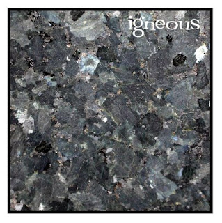
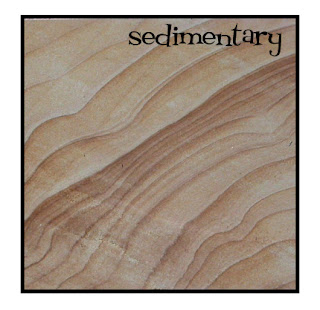
Here are some pictures from UCDavis, University of California to help see better.
Chapter 13:
This is very straightfoward, you should be able to ace this.
Know the earth water distribution in percentage and why it is important to conserve water.
The water cycle: what happens at percipitation, transpiration, condensation, surface runoff and groundwater flow.
Each drainage basin is seperated by a watershed
Parts of the river:
Upper course: (in descending order)
River source (part of the drainage basin)
Tributaries(part of the drainage basin)
Waterfall (find out how they are formed, remember the hard rock comes before the soft rock)
valley
Middle course:
meander (can also be found in the middle-lower course too)
Lower course:
Floodplain
Delta (river mouth, formed by deposition of sediments)
Note that as the river flows down from the mountain, the water will flow slower as the gradient of the land become gentler towards the sea and there is less gravity pull on the water.
Tuesday, May 1, 2007
Exam Tip 3 @ 9:30 AM
For the next 3 chapters, chapters 4-6, you have to take note of the following:Chapter 4:
Know the purpose and a general idea of what each map is.
Know your latitude (horizontal lines, running from 90N to 90S) and longitude (vertical lines, running from 180E to 180w)
For express students, you also need to know what is the international dateline is and how to read the different time zone. A simple method to rememeber is when the question ask you what time is country X is when Country Y is 9am.
1. count the difference in the number of hours between each country by looking at the timechart below (use your textbok page 34 for reference).
2. Minus the hours from 9am if the country X is to the left of country Y and add the hours to 9am if country X is right to country Y.
Chap 5:
Mapwork, something I have repeated countless times.
1. Know the parts of the maps like in page36 and 37 of your textbook.
2. Know how to use the scale, remember that the scale is always in cm, unless otherwise stated and convert the final value to Km.
3. 4 and 6 grid reference, read the easting value (values at the bottom part of the map running from left to right), then the northing value (values at the left side of the map running from bottom to top). 6 grid reference must always be taken with estimation the 3rd and 6th values can only be from 0 to 9. If the 3rd and 6th values is 0, then point will cut across the gridline.
4. Compass direction, if the question ask you to find the compass direction of A from B. READ FROM B!!! THAT MEANS THE POINT OF REFERENCE IS B, NOT A!!!!
5. Bearings, check my previous post.
6. Cross section of landforms, here are a few things for you all to take note:
a. Draw your cross section line first.
b. Draw your contour lines and add the contour values into the cross section box. Remember the bottom part of the box is '0' metres.
c. Draw straight lines down from each contour line to the the respective contour line in the contour box with a ruler.
d. Use freehand and join the points where the lines cross each other and the shape must start from the bottom and the highest point must be slightly higher than the highest contour line.
Chap 6:
There are 3 types of photograpghs: Landscape, aerial and satellite and there are mainly 2 types of human settlements, urban and rural.
Be able to recognise what is human features and physical features. The more buildings there are, the more urban it will be is a good rule of thumb.
Landscape photographs can be splitted in foreground, midground and background. Be able to describe each part with at least one detail. It is unlikely that you will find one with nothing to describe.
That is all for now.
Monday, April 23, 2007
Exam Tip 2 @ 7:56 AM
A conglomerate is a sedimentary rock that comprises of different types of rocks cemented together. Secondly a schist is form of metamorphic rock.First of all, here are a few tips to remember for the first 3 chapters.
Earth rotates 24 hours a day and revolves 365 1/4 days per year and orbits at 66 1/2 degrees to the plane of orbit.
A good steward is an individual that helps protect the Earth from environmental damage.
Physical enviornment - an environment untouched by man.
Human environment - an environment created by man to suit his needs.
Physical feature - a feature created by nature.
Human feature - a feature created by man.
A rural settlement is a human environment with low human density, few human features and high physical features.
An urban settlement is a human environment whith high human density, high human features and low physical features.
The !kung bushmen adapts to their environment by taking only what they need.
The city people change their environment to suit to their needs.
The methods of adaptation by both city people and the bushmen, I will leave it to you to read the textbook.
I will update more on the following chapters in time to come.
Friday, April 20, 2007
Exam tips @ 8:39 AM
Let me address some of the problems at hand first that came on the tagboard, you can post as me as much as you want, but you cannot get into the blog, so a big 'HAHAHAHAHA' to you all posers.Secondly, a few questions that came up on the blog.
Fieldwork-It is to go out to the site or area of concern to do research on the topic that is being investigated. For example, I want to find out how many bugs are there in a park, so I go to a park and start taking samples from random places around the park and count how many bugs there are.
Crustal movement- it is the movement of the crustal plates caused by the convection currents of heat moving in the mantle. when two currents meet, thecrustal plates will collide towards each other. When the currents move away from one another, the crustal plates will seperate.
In regards to the other chapters, I will update again tomorrow, I am very tired now, need to sleep.
Thursday, April 19, 2007
Of remedials, tests and exam. @ 8:20 AM
Dear all sec-one-ders, I have finish marking your test papers. One word, BAD. I clearly can see many of you never study. As a result, I will from now onwards for this year, provide you with pre-emptive tips (early warning) for every lessons and events (test, exams, etc) on my blog. It is then on the effort of everyone to check my blog (blog committee, please help to spread the info to your resepective classes).REMEDIAL
First of all, the issue of remedial. The following dates are set out according for each class at the AVA room.
Monday, 23rd April 2007, 2.00pm-3.00pm: Sec 1A, 1C.
Tuesday, 24th April 2007, 2.00pm-3.00pm: Sec 1E, 1F.
Tuesday, 24th April 2007, 3.00pm-4.00pm: Sec 1B.
Wednesday, 25th April 2007, 2.00pm-3.00pm: Sec 1G, 1H.
Assessment Referral Books
There are 5 assesment books in the library for everyones' use. You can use it to help you prepare attempting questions that are different in approaches. Unfortunately, you cannot take the books out. Among the books, there is Earth, Our Home Guidebook, it is really good and it is written by none other than our vice-principal, Mr Nathan. I strongly recommend having a copy for your own use.
EXAMS
Exams will be on the 8th May 2007, Tuesday. Exam topics will cover from chapter 1 to chapter 13, excluding chapter 7. You will have MCQs, mapwork, photo intepretations, short answer questions and you have to answer 3 out of 5 structured questions based on the heavier content chapters.
I will be posting more tips for all of you in the next following days to come., but here are some basic things to look out for each chapter.
Chapter 1: What is a physical or human environment? What is a physical or human feature?
Chapter 2: The Earth's rotation, revolution, time and what is a good steward?
Chapter 3: What is the relationship betwen man and his environment (both physical and human)
Chapter 4: The types and uses of maps, What is latitude, longitude, greenwich or prime meridian, equator, International Date Line & time zones (for express students only), How to read longitiude and latitude.
Chapter 5 (the killer): 4-grid reference, 6-grid reference, Easting, Northing, scales, compass direction, measuring distances, bearings, Drawing cross sections of landforms (with all the required parts)
Chapter 6: the 3 types of photographs, their advantages and disadvantages, how to see the foreground, midground and background of landscape photographs, recognising human and physical features, rural or urban environment.
Chapter 8: Explaining the 5 types of landforms, describe the positive and negative effects of landforms.
Chapter 9: Where is the core, mantle and crust? How is crustal movement caused by convection current in the mantle? What is folding and fold mountains? what happens when plates move away and towards each other? What is vulcanicity? What is the relationship betwen magma, lava & cinder? How is vulcanic eruption caused by? The parts of a volcano. How is a cone volcano created? What is active, dormant and extinct volcano?
Chapter 10: Risks and benefits of living with a volcano.
Chapter 11: Describing the 3 types of mechanical weathering, chemical weathering, erosion, by wind, water and waves. What is weathering and what is erosion?
Chapter 12: Explain the formation and features of the 3 types of rocks, 3 examples of each type of rock, how does one rock change to another in a rock cycle.
Chapter 13: The amount of water distributed in the world, describe briefly each part of the hydrological cycle, what is a tributary, distrubtary, drainage basin and watershed? Recongnise the parts of the river system like river source, meander, delta, etc.
If you can answer all the questions here, you are certain to pass the exams. Post more queries when in doubt, I will now check every night to post up answers to your questions. Blog committee, please inform the class of this recent tips, thanks.
Wednesday, April 18, 2007
Global Dimming @ 10:06 PM
Well, here are the links of what I was talking about global dimming. It is the new twist to how the world might end. I would like you all to think how does the lack of sunlight will kill the world and what we can do to save the world. The answer is very easy, but strange and sad thing (like you teacher, =P) is that most of the world can't seem to accept the answer as a solution. Think about the answer if you can and post it up.http://en.wikipedia.org/wiki/Global_dimming
http://www.bbc.co.uk/sn/tvradio/programmes/horizon/dimming_prog_summary.shtml
A very controversial program about global dimming:
http://www.informationclearinghouse.info/article15809.htm
Here is a famous blog on global environmental issues and their take on global dimming.
http://www.globalissues.org/EnvIssues/GlobalWarming/globaldimming.asp
Another good video:
http://www.pbs.org/wgbh/nova/sun/dimming.html
Anyway, don't dread too much, Scientist has put the dateline when we really suffer the effects of it and the possible point of no return at about 10 years from now, so you will be about 23 years old. At least, if the world ends, you be an adult. So put a smile on your face, Mother Earth has awhile to live and yes, it is not tested.
Thursday, April 12, 2007
@ 6:12 AM
TO OBTAIN AND LEARN YOUR GEOGRAPHICAL SKILLS VIST THESE WEBSITES:
FOR PHOTOS SKILLS:
FOR MAP SKILLS:
http://www.bbc.co.uk/schools/gcsebitesize/geography/geogskills/geogskillsmapsrev1.shtml
Monday, April 9, 2007
Fine grained and coarse grained igneous rocks @ 7:02 PM
To sec 1C, 1E, 1F and 1H, I apologise for making a mistake. granite is coarse grained and pumice is fine grained. Pumice is fine grained as it cools faster, so the crystals become small and do not have the effect of the heat to expland the crystals slowly.If you need more help to clarify this matter, please look for me. Thank you.
Saturday, April 7, 2007
Mapwork @ 7:11 AM
As promised, I will show you all again the step by step procedures of the common map work techniques for you all.First we will start with compass direction.
Let's look at how a question will be phrased, "what is the compass direction of the city from the farm. take note of the "from" word in the question, it indicates the location you should take your reading from.
Follow the following steps to get the answer.
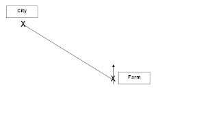
1. Draw a north line on the farm.
2. Draw a connectiong line between the farm and the city.
3. base on the north arrow, find out where the connecting line is located at.
The connecting line lies in the Northwest region, so the city is Northwest of the farm.
Bearings
Let's use the same qustion as above, but we will now find the bearings. So the question will go like "What is the bearing of the city from the farm?"
Repeat the first 2 steps like in finding compass direction, then draw a clockwise circle starting from the north arrow to the connecting line, just like in the picture below.
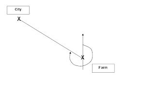
1. Draw a north line on the farm.
2. Draw a connectiong line between the farm and the city.
3. Draw a clockwise circle starting from the north arrow to the connecting line.
4. Use a protractor to find the angle starting from the north arrow, the diagram below will give a good idea wha the bearings should be.
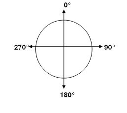
Based on the diagram above, we can see that the angle should be between 270 degrees and 359 degrees. Remember that bearings only range from 0 degrees to 359 degrees. 360 degrees is the same as 0 degrees.
Gradient
Many students have come to ask me about this. The gradient is simply height over distance or height/distance. the questions can vary in regards to gradient, but the formula does not.
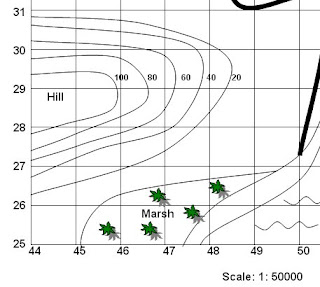
here is an example of how a question can go about. Look at the part of the map above (looks familiar? ;P) Find the graident of the slope along northing line 29. Do the following steps to get your answer.
1. Locate northing line 29.
2. Find the highest and lowest contour line on the northing line 29.
3. find the difference betweem the highest and lowest contour line, which in this case is 100-20=80m. Remember contour lines are always measured in metres.
4. Next, use a ruler to find the distance of the northing line 29 from the side of the map to the lowest contour line, that will be your distance.
5. Multiply the distance with the scale which is 1: 50,000 on this map (look at the bottom part of the map), remember to convert to metres (divide by 100). All scales are in centimetres, unless specified otherwise.
6. Finally, divide the height by the distance and reduce the answer to a ratio of 1: distance. For example in this case, let's assume the distance is 1000m. So the gradient is 80/1000 which is then reduced to 1:125. That means for every 125m that you walk on the hill, you go up by 1m.
I will cover the rest on mapwork if need be, but I think the rest you all are able to handle so far.
Sunday, April 1, 2007
Volcano-boom! Chakalala! Boom! @ 4:32 AM
here is a simple site for you all to see about volcanoeshttp://www.projectshum.org/NaturalDisasters/volcano.html
Here is a google site for the different locations of volcanoes in the world.
http://www.worldvolcanoes.info/map.html
here is a good site to find tons of excellent videos about the earth. Use the search function to find more videos, I bet you can at the computer the whole day through with this site. This not only for volcanoes, but for many other materials.
http://dsc.discovery.com/beyond/
This site is more for the hardcore who really want to know more.
http://science.howstuffworks.com/volcano.htm/printable
Hope you find this sites interesting!
Earth Day competition dateline extended @ 4:27 AM
Good news everyone, the dateline of the competition has been extended to 11th April 2007, Wednesday. I sincerely hope this is enough time for all. Make sure you have your groups by now, geog reps, please take note of this and ensure that you have the namelist by now. Good luck everyone, may the force of Gaia (mother nature) guide your Earth skill!Wednesday, March 28, 2007
Map work retest @ 8:25 AM
Please take note that the retest will be done next week in the afternoon after school. I will come to your class and inform you when the test will be.You can check this site to help you understand better.
http://www.bbc.co.uk/schools/gcsebitesize/geography/geogskills/geogskillsmapsrev1.shtml
Look at the basics of map reading 1 and 2, they provide good material.
Earth day badge design and poster @ 8:02 AM
As in regards to a post here, the badge is 5.5cm in diameter. In your group, design a badge on a piece of paper and write a summary of about 100 words explaining your design under the design itself. The top group will win a prize and a grand prize among the other top groups in the level.I also understand some of you have problem understanding what to do for the competition. Essentially, you have to design your badge or poster with regards to Earth Day. The theme of your design can vary from the 3 Rs, reducing pollution, protecting our ecosystem, conserving our resources or anything that helps the Earth.
If you are in doubt, post again, but state your questions clearly, I cannot understand brief statements.
Tuesday, March 20, 2007
Earth Day Competition @ 9:19 PM
Bad news and good news! There is now 2 competitions that you have to compete in. The first is making the 'Save the Environment' badge logo and an A4 poster on Earth Day theme. The good news is that the dateline has now been pushed to 2nd April 2007, Wednesday in the first week of April for both of them.The requirement for the Earth Day Competition are as follow:
1. Get into groups of 4 with a minimum of 3 members (this is for classes with odd number of students)
2. Using a piece of A4 paper for both your competition entries.
3. The size of the badge design should be 5.5cm in diameter. (Diameter has been changed) Write a short passage of about 100 words describing your choice of design below the badge design and include your team members names, class index and class.
4. The poster must be done on an A4 size paper and it must be based on the theme of 'Earth Day'. Ensure that you place your team members' name, class index and class at the back of the paper.
5. Staple your work together and submit it to your respective Geography IC by 2nd April 2007.
You can find out more about Earth Day on these sites:
http://www.earthday.org/
http://www.epa.gov/earthday/
http://www.earthday.gov/
Saturday, March 10, 2007
Been sick the past week, but here is the headlines @ 11:06 PM
A big sorry to everyone, I have been sick the past week and I haven't really been updating my post as of yet. Anyway, like to point out a few important things for all of you.Firstly, in the new set of worksheet I handed out, please skip page 3 all together, it is too hard.
Secondly, on page 2, draw a line across the slope on the top right hand corner of the map and label both ends with 'B' an 'C', this is for question 3 on the same page.
Thirdly, I will be covering mainly chapter 5 for the remedial and again I stress it is mainly for those that had failed in the previous common test.
Now some of you might be also wondering why your grades in your report card with that of your common test, it is because I had to add in your class test results and that lead to the change in the final results.
Finally, I would like to extend a warm welcome to my blogging committee, but I am still missing out on 1F and 1G bloggers, could someone in either class please volunteer, as I have some activities for you all to do.
Wednesday, February 28, 2007
Updates on lessons @ 7:42 PM
I will be finishing chapter 5 next week and I will be giving out a class quiz for you all to do. Additionally, I like you all to do review exercise page 49 to 55 in your workbook for your 1 week holiday. This should prepare you for the class test that will be held in the third week of March, 2007. The class test will cover chapter 4 and 5.Blogging Committee @ 7:37 PM
I am going to start a mini blogging committee with a representative from each class, among them a leader and assistant leader will be selected too. I will like to hear from the rest of you how we can make this blog more interactive for everyone to be involved.I would like some students from each class to contribute some things they have learn in class or on their own. This will be posted up on the blog with their photos (or not if you are not comfortable).
I guess the task to help me out with the blog would be of great interest to the committee, but I would like to add that any material that is to be posted on the blog have to be emailed to me for approval.
Again, suggestions and more suggestions please. Like I said many times before, I set the paper, you sit the paper. May the study force be with you.
Monday, February 26, 2007
International Dateline, Prime Meridian and Greenwich Meridian @ 6:39 AM
I think I need to clarify some matters on the International Dateline, Prime Meridian and Greenwich Meridian. First of all, the 0° longitude is not the international dateline, it is known as the prime meridian or Greenwich meridian. The 180° longitude line halfway across the world is the international dateline.Please note that only the express stream will be tested on this material.
The key confusion alot of you seems to have is how people loses and gain one day. A easy way to understand this part is that you must first accept that at the 180° longitude, people west of this line is a full day earlier than those on the east.
If you are going westwards from the prime meridian to the international dateline, you minus an hour for every 15° you travel westwards on the planet and add an hour for every 15° you travel eastwards on the planet.
Check up on this sites if you want find out more about the international dateline,
http://geography.about.com/od/physicalgeography/a/idl.htm
http://en.wikipedia.org/wiki/International_Date_Line
http://www.answers.com/topic/international-date-line
Remedials, study groups and extra stuff @ 6:22 AM
It seems alot of you are very interested in learning alot more and really want to make a new design for this site, I am all for it. If you want to do so, please leave your name, class and class index on the comment page. I will get back to you and I might start a blogging committee for the sec 1.I got a comment on the study groups too that some of you want to go solo on your quest, it is fine by me, like I said: I set the paper, you sit the paper. If you think you do better going on your own, I am fine with it too. As for remedials and study group, I will be starting one up by next week. Places will be limited and those that have failed the common test will have 'special priviledge' of having the first priority. Lessons as usual will be upstairs in the IT Resource Room 1 probably about at 2.30pm (I have to eat my lunch first) and go on for an hour. lessons will be informal and the focus will be on areas that you are weak on. Note that study groups can join in too, but do not be surprise if I take some of you to help teach you schoolmates.
Lastly, if you do start your study group, stick with it and try out other chapters on your own if the interest compels you to do so. So go forth and venture into the dark!
Sunday, February 25, 2007
Ownership @ 7:44 PM
I had several students last week looking for remedial and more homework, I am very happy to see that some of you are beginning to take ownership of your studies. I shared some suggestions with them that I would to share with the rest of you too. First of all, I like to point out I am not going to enforce or insist that you must do so, but I am strongly recommending it.Get into groups of 4 to 5 and buy external assesment books to do. That way you can split the cost of the book and you can come together to discuss your answers too. The benefits of doing this is 2 folds, firstly you can improve on your answering techniques on different types of questions and compare your answering with the answers at the back, secondly you become more confident in Geography and learn to take ownership of your studies.
Don't worry about trying questions that is outside of the chapters that I have not covered, it is fine, by taking the effort to move ahead of your teacher is exactly what I want, afterall it is all teacher's hope that their students become better than their teacher.
Here are some examples of books that you can try, don't worry I am not the companies sales representatives.
Longman Geography: Revsion Guide Sec 1
Penman's: Student's Companion Series, Geography Sec 1
I will try to look up for more other assessment books.
Topographical Features @ 7:40 PM
Check this link on more detailed descriptions on topographical features, this will helpp you greatly in understanding page 48-50 of your textbook, under chapter 5.http://reynolds.asu.edu/topo_gallery/topo_gallery.htm
Just look at the simple features on this link, it is not necessary to look up on the complex features.
How to study geography @ 6:10 AM
There are many ways in studying, but my personal opinion is that understanding is the key to get the most of your studies. The 2 main methods I normally use and encourage in Geography is to:1. Mindmap-
Break down your chapters into topics, sub-topics and details. Add on more links when you learn more. In fact, all the chapters in your textbook are connected one or another.
2. The 5 Ws-
What happened
Who was involved
When did it happen
Where did it happen
Why did it happen
The 5 Ws are the key in understanding any event or subject, by answering those questions will help you with better understanding of any topic.
Take note that tips are not to help you directly getting better results in your tests or exams, because another factor has to be taken into account, which is answering correctly.
Friday, February 23, 2007
Common test 1-2007 review @ 5:23 PM
So far there has been a mix of passes and failures, but mainly passes. Strangely, I have only one full marker with many many others breathing down his neck. I like to address a few things that I have came across when I was marking the paper that I want to bring up to everyone.
1. Things, objects, details & features-using the terms correctly
I give some of you the benefit of the doubt on the use of your english for this paper and I have closed one eye on your language, since the objective of the paper is to gauge your understanding of Geography and not your english. Nonetheless, make it a concentious effort to use the right wording. Things and objects are all reference to the word feature. Details are not. Details are descriptions of the feature, so if you are using the word details, you have to use the word feature along with it. For example, 'The details of the features are...' So be careful in your writing.
2. Rural & urban-the difference
There are still some people struggling with the term rural and urban. PLEASE REMEMBER: A rural settlement is a place with few buildings like a village or a 'kampung'. A urban settlement is a place with alot of buildings like a city or town. Do not describe the activity there as a form of settlement, unless I specify in the question.
3. Read your questions and answers carefully
The age old problem with students, I still have students not answering to the questions. READ the question carefully before answering. Lastly, READ your answers before submitting, I have a few cases of students writing the right answer for the wrong question.
Please take note that aside from this issues that I have highlighted, I also do note that many girls have a problem answering correctly to the point, although you may have gotten some marks for your answer, it was mainly based on the strength of youe english to pull your results up, but it will not be helpful for the next class test on chapter 4 and 5 which will be on purely understanding.
Tuesday, February 20, 2007
My favourite links @ 5:48 PM
Here are some of my favourite Geography links, you can find alot of information here about Geography.On matters about the physical environment and our natural resources:
www.mongabay.com
On weathers, climate and pollution:
http://www.epa.gov/epahome/topics.html
On all other stuff that you might need to find:
http://wikipedia.org
There are many more other sites that I will post up, so keep yourself updated on this blog.
If you have any other sites you like to share, please put up your comments.
Here are more sites that I find is useful:
http://www.geography.about.com
http://www.answers.com