Monday, April 23, 2007
Exam Tip 2 @ 7:56 AM
A conglomerate is a sedimentary rock that comprises of different types of rocks cemented together. Secondly a schist is form of metamorphic rock.First of all, here are a few tips to remember for the first 3 chapters.
Earth rotates 24 hours a day and revolves 365 1/4 days per year and orbits at 66 1/2 degrees to the plane of orbit.
A good steward is an individual that helps protect the Earth from environmental damage.
Physical enviornment - an environment untouched by man.
Human environment - an environment created by man to suit his needs.
Physical feature - a feature created by nature.
Human feature - a feature created by man.
A rural settlement is a human environment with low human density, few human features and high physical features.
An urban settlement is a human environment whith high human density, high human features and low physical features.
The !kung bushmen adapts to their environment by taking only what they need.
The city people change their environment to suit to their needs.
The methods of adaptation by both city people and the bushmen, I will leave it to you to read the textbook.
I will update more on the following chapters in time to come.
Friday, April 20, 2007
Exam tips @ 8:39 AM
Let me address some of the problems at hand first that came on the tagboard, you can post as me as much as you want, but you cannot get into the blog, so a big 'HAHAHAHAHA' to you all posers.Secondly, a few questions that came up on the blog.
Fieldwork-It is to go out to the site or area of concern to do research on the topic that is being investigated. For example, I want to find out how many bugs are there in a park, so I go to a park and start taking samples from random places around the park and count how many bugs there are.
Crustal movement- it is the movement of the crustal plates caused by the convection currents of heat moving in the mantle. when two currents meet, thecrustal plates will collide towards each other. When the currents move away from one another, the crustal plates will seperate.
In regards to the other chapters, I will update again tomorrow, I am very tired now, need to sleep.
Thursday, April 19, 2007
Of remedials, tests and exam. @ 8:20 AM
Dear all sec-one-ders, I have finish marking your test papers. One word, BAD. I clearly can see many of you never study. As a result, I will from now onwards for this year, provide you with pre-emptive tips (early warning) for every lessons and events (test, exams, etc) on my blog. It is then on the effort of everyone to check my blog (blog committee, please help to spread the info to your resepective classes).REMEDIAL
First of all, the issue of remedial. The following dates are set out according for each class at the AVA room.
Monday, 23rd April 2007, 2.00pm-3.00pm: Sec 1A, 1C.
Tuesday, 24th April 2007, 2.00pm-3.00pm: Sec 1E, 1F.
Tuesday, 24th April 2007, 3.00pm-4.00pm: Sec 1B.
Wednesday, 25th April 2007, 2.00pm-3.00pm: Sec 1G, 1H.
Assessment Referral Books
There are 5 assesment books in the library for everyones' use. You can use it to help you prepare attempting questions that are different in approaches. Unfortunately, you cannot take the books out. Among the books, there is Earth, Our Home Guidebook, it is really good and it is written by none other than our vice-principal, Mr Nathan. I strongly recommend having a copy for your own use.
EXAMS
Exams will be on the 8th May 2007, Tuesday. Exam topics will cover from chapter 1 to chapter 13, excluding chapter 7. You will have MCQs, mapwork, photo intepretations, short answer questions and you have to answer 3 out of 5 structured questions based on the heavier content chapters.
I will be posting more tips for all of you in the next following days to come., but here are some basic things to look out for each chapter.
Chapter 1: What is a physical or human environment? What is a physical or human feature?
Chapter 2: The Earth's rotation, revolution, time and what is a good steward?
Chapter 3: What is the relationship betwen man and his environment (both physical and human)
Chapter 4: The types and uses of maps, What is latitude, longitude, greenwich or prime meridian, equator, International Date Line & time zones (for express students only), How to read longitiude and latitude.
Chapter 5 (the killer): 4-grid reference, 6-grid reference, Easting, Northing, scales, compass direction, measuring distances, bearings, Drawing cross sections of landforms (with all the required parts)
Chapter 6: the 3 types of photographs, their advantages and disadvantages, how to see the foreground, midground and background of landscape photographs, recognising human and physical features, rural or urban environment.
Chapter 8: Explaining the 5 types of landforms, describe the positive and negative effects of landforms.
Chapter 9: Where is the core, mantle and crust? How is crustal movement caused by convection current in the mantle? What is folding and fold mountains? what happens when plates move away and towards each other? What is vulcanicity? What is the relationship betwen magma, lava & cinder? How is vulcanic eruption caused by? The parts of a volcano. How is a cone volcano created? What is active, dormant and extinct volcano?
Chapter 10: Risks and benefits of living with a volcano.
Chapter 11: Describing the 3 types of mechanical weathering, chemical weathering, erosion, by wind, water and waves. What is weathering and what is erosion?
Chapter 12: Explain the formation and features of the 3 types of rocks, 3 examples of each type of rock, how does one rock change to another in a rock cycle.
Chapter 13: The amount of water distributed in the world, describe briefly each part of the hydrological cycle, what is a tributary, distrubtary, drainage basin and watershed? Recongnise the parts of the river system like river source, meander, delta, etc.
If you can answer all the questions here, you are certain to pass the exams. Post more queries when in doubt, I will now check every night to post up answers to your questions. Blog committee, please inform the class of this recent tips, thanks.
Wednesday, April 18, 2007
Global Dimming @ 10:06 PM
Well, here are the links of what I was talking about global dimming. It is the new twist to how the world might end. I would like you all to think how does the lack of sunlight will kill the world and what we can do to save the world. The answer is very easy, but strange and sad thing (like you teacher, =P) is that most of the world can't seem to accept the answer as a solution. Think about the answer if you can and post it up.http://en.wikipedia.org/wiki/Global_dimming
http://www.bbc.co.uk/sn/tvradio/programmes/horizon/dimming_prog_summary.shtml
A very controversial program about global dimming:
http://www.informationclearinghouse.info/article15809.htm
Here is a famous blog on global environmental issues and their take on global dimming.
http://www.globalissues.org/EnvIssues/GlobalWarming/globaldimming.asp
Another good video:
http://www.pbs.org/wgbh/nova/sun/dimming.html
Anyway, don't dread too much, Scientist has put the dateline when we really suffer the effects of it and the possible point of no return at about 10 years from now, so you will be about 23 years old. At least, if the world ends, you be an adult. So put a smile on your face, Mother Earth has awhile to live and yes, it is not tested.
Thursday, April 12, 2007
@ 6:12 AM
TO OBTAIN AND LEARN YOUR GEOGRAPHICAL SKILLS VIST THESE WEBSITES:
FOR PHOTOS SKILLS:
FOR MAP SKILLS:
http://www.bbc.co.uk/schools/gcsebitesize/geography/geogskills/geogskillsmapsrev1.shtml
Monday, April 9, 2007
Fine grained and coarse grained igneous rocks @ 7:02 PM
To sec 1C, 1E, 1F and 1H, I apologise for making a mistake. granite is coarse grained and pumice is fine grained. Pumice is fine grained as it cools faster, so the crystals become small and do not have the effect of the heat to expland the crystals slowly.If you need more help to clarify this matter, please look for me. Thank you.
Saturday, April 7, 2007
Mapwork @ 7:11 AM
As promised, I will show you all again the step by step procedures of the common map work techniques for you all.First we will start with compass direction.
Let's look at how a question will be phrased, "what is the compass direction of the city from the farm. take note of the "from" word in the question, it indicates the location you should take your reading from.
Follow the following steps to get the answer.
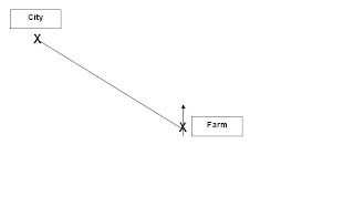
1. Draw a north line on the farm.
2. Draw a connectiong line between the farm and the city.
3. base on the north arrow, find out where the connecting line is located at.
The connecting line lies in the Northwest region, so the city is Northwest of the farm.
Bearings
Let's use the same qustion as above, but we will now find the bearings. So the question will go like "What is the bearing of the city from the farm?"
Repeat the first 2 steps like in finding compass direction, then draw a clockwise circle starting from the north arrow to the connecting line, just like in the picture below.
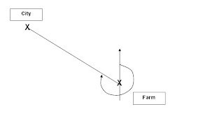
1. Draw a north line on the farm.
2. Draw a connectiong line between the farm and the city.
3. Draw a clockwise circle starting from the north arrow to the connecting line.
4. Use a protractor to find the angle starting from the north arrow, the diagram below will give a good idea wha the bearings should be.
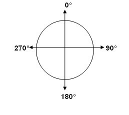
Based on the diagram above, we can see that the angle should be between 270 degrees and 359 degrees. Remember that bearings only range from 0 degrees to 359 degrees. 360 degrees is the same as 0 degrees.
Gradient
Many students have come to ask me about this. The gradient is simply height over distance or height/distance. the questions can vary in regards to gradient, but the formula does not.
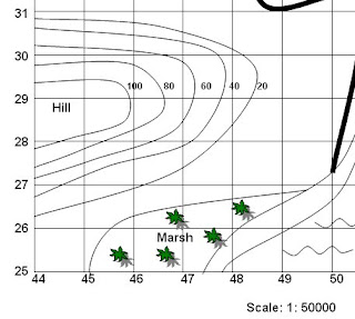
here is an example of how a question can go about. Look at the part of the map above (looks familiar? ;P) Find the graident of the slope along northing line 29. Do the following steps to get your answer.
1. Locate northing line 29.
2. Find the highest and lowest contour line on the northing line 29.
3. find the difference betweem the highest and lowest contour line, which in this case is 100-20=80m. Remember contour lines are always measured in metres.
4. Next, use a ruler to find the distance of the northing line 29 from the side of the map to the lowest contour line, that will be your distance.
5. Multiply the distance with the scale which is 1: 50,000 on this map (look at the bottom part of the map), remember to convert to metres (divide by 100). All scales are in centimetres, unless specified otherwise.
6. Finally, divide the height by the distance and reduce the answer to a ratio of 1: distance. For example in this case, let's assume the distance is 1000m. So the gradient is 80/1000 which is then reduced to 1:125. That means for every 125m that you walk on the hill, you go up by 1m.
I will cover the rest on mapwork if need be, but I think the rest you all are able to handle so far.
Sunday, April 1, 2007
Volcano-boom! Chakalala! Boom! @ 4:32 AM
here is a simple site for you all to see about volcanoeshttp://www.projectshum.org/NaturalDisasters/volcano.html
Here is a google site for the different locations of volcanoes in the world.
http://www.worldvolcanoes.info/map.html
here is a good site to find tons of excellent videos about the earth. Use the search function to find more videos, I bet you can at the computer the whole day through with this site. This not only for volcanoes, but for many other materials.
http://dsc.discovery.com/beyond/
This site is more for the hardcore who really want to know more.
http://science.howstuffworks.com/volcano.htm/printable
Hope you find this sites interesting!
Earth Day competition dateline extended @ 4:27 AM
Good news everyone, the dateline of the competition has been extended to 11th April 2007, Wednesday. I sincerely hope this is enough time for all. Make sure you have your groups by now, geog reps, please take note of this and ensure that you have the namelist by now. Good luck everyone, may the force of Gaia (mother nature) guide your Earth skill!