Saturday, April 7, 2007
Mapwork @ 7:11 AM
As promised, I will show you all again the step by step procedures of the common map work techniques for you all.First we will start with compass direction.
Let's look at how a question will be phrased, "what is the compass direction of the city from the farm. take note of the "from" word in the question, it indicates the location you should take your reading from.
Follow the following steps to get the answer.
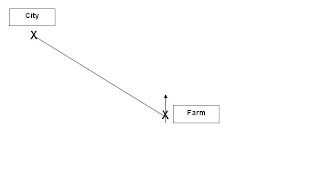
1. Draw a north line on the farm.
2. Draw a connectiong line between the farm and the city.
3. base on the north arrow, find out where the connecting line is located at.
The connecting line lies in the Northwest region, so the city is Northwest of the farm.
Bearings
Let's use the same qustion as above, but we will now find the bearings. So the question will go like "What is the bearing of the city from the farm?"
Repeat the first 2 steps like in finding compass direction, then draw a clockwise circle starting from the north arrow to the connecting line, just like in the picture below.
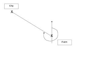
1. Draw a north line on the farm.
2. Draw a connectiong line between the farm and the city.
3. Draw a clockwise circle starting from the north arrow to the connecting line.
4. Use a protractor to find the angle starting from the north arrow, the diagram below will give a good idea wha the bearings should be.
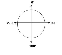
Based on the diagram above, we can see that the angle should be between 270 degrees and 359 degrees. Remember that bearings only range from 0 degrees to 359 degrees. 360 degrees is the same as 0 degrees.
Gradient
Many students have come to ask me about this. The gradient is simply height over distance or height/distance. the questions can vary in regards to gradient, but the formula does not.
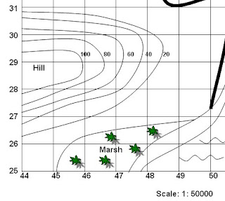
here is an example of how a question can go about. Look at the part of the map above (looks familiar? ;P) Find the graident of the slope along northing line 29. Do the following steps to get your answer.
1. Locate northing line 29.
2. Find the highest and lowest contour line on the northing line 29.
3. find the difference betweem the highest and lowest contour line, which in this case is 100-20=80m. Remember contour lines are always measured in metres.
4. Next, use a ruler to find the distance of the northing line 29 from the side of the map to the lowest contour line, that will be your distance.
5. Multiply the distance with the scale which is 1: 50,000 on this map (look at the bottom part of the map), remember to convert to metres (divide by 100). All scales are in centimetres, unless specified otherwise.
6. Finally, divide the height by the distance and reduce the answer to a ratio of 1: distance. For example in this case, let's assume the distance is 1000m. So the gradient is 80/1000 which is then reduced to 1:125. That means for every 125m that you walk on the hill, you go up by 1m.
I will cover the rest on mapwork if need be, but I think the rest you all are able to handle so far.